Mining Exploration: Cameroon Chooses Airborne Survey
By Godlove BAINKONG, Cameroon Tribune, 21-01-2014
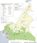 Against a backdrop of insufficient knowledge on the mineral potentials
of about 60 per cent of the national territory, the government of
Cameroon has opted for an airborne geophysical survey to explore the
uncovered part. This is through a one and half-year project (January
2014 to June 2015) code-named, “Airborne Geophysical Survey Campaign” to
cover a surface area of 187,200 km in the North, Adamawa, East, West,
Littoral and Centre Regions.
Against a backdrop of insufficient knowledge on the mineral potentials
of about 60 per cent of the national territory, the government of
Cameroon has opted for an airborne geophysical survey to explore the
uncovered part. This is through a one and half-year project (January
2014 to June 2015) code-named, “Airborne Geophysical Survey Campaign” to
cover a surface area of 187,200 km in the North, Adamawa, East, West,
Littoral and Centre Regions.
MINMIDT boss explained the workability of a project to this effect to the press on Tuesday January 21, 2014.
In a
press briefing in Yaounde yesterday January 21 to explain the raison
d’être of the project jointly funded by the World Bank and the
government,
the Minister of Industries, Mines and Technological
Development (MINMIDT), Emmanuel Bonde, said the process will consist in
well-equipped planes carrying mining experts and security men flying at
low altitude over the concerned areas in view of achieving an inventory
through the mapping out of the mining potentials of the areas. He
disclosed that the areas concerned by the flying activity include
Ndikiminiki, Bafia, Linte, Nanga Eboko, Bertoua, Deng-Deng, Ngaoundere,
Tibati, Poli, Tchamba as well as Bafoussam and its environs among
others.
Flanked
by the Secretary of State in MINMIDT, Dr Fuh Calistus Gentry, Minister
Bonde noted that inhabitants of these localities will in the days ahead
witness the survey planes flying as proof of mining exploration. The
project will be carried out by a Canadian Company, Geotech Airborne
Limited, specialised in the field and which officials said has so many
years of experience acquired in countries with established mining
potentials like Niger, Mozambique, Namibia and Tanzania among others. >>>
Commentaires
Enregistrer un commentaire